Digital Equity Resources for Researchers
What is Digital Divide?
 The digital divide is defined as the economic, educational, and social inequalities between those who do and do not:
- Have access to modern information and communication technology including computers and the internet; and
- Possess the digital literacy necessary to make full use of that technology.
In the education setting, students that do not have access to an adequate computing device, stable internet, or that lack the skills needed to utilize both, are at increased risk for disengagement which can lead to learning loss and the inability to master instructional content and complete homework assignments.
Issues that stem from the digital divide have been exacerbated by the COVID-19 public health epidemic which prompted widespread school and business closures. In response, schools shifted to distance learning instructional models which left students without computers and internet at increased risk for poor academic, social-emotional, and behavioral outcomes.
A series of pilot projects with schools were undertaken to explore technology options to increase broadband access at home during 2020-2021. This White Paper examines the challenges faced in those projects, the solutions applied to address various problems, and discusses ways the work can be applied to a better future for educational broadband.
The initial team for this project consisted of the Santa Clara County Board of Supervisor Susan Ellenberg, the Santa Clara County Office of Education, and Joint Venture Silicon Valley.
Digital Divide Geography
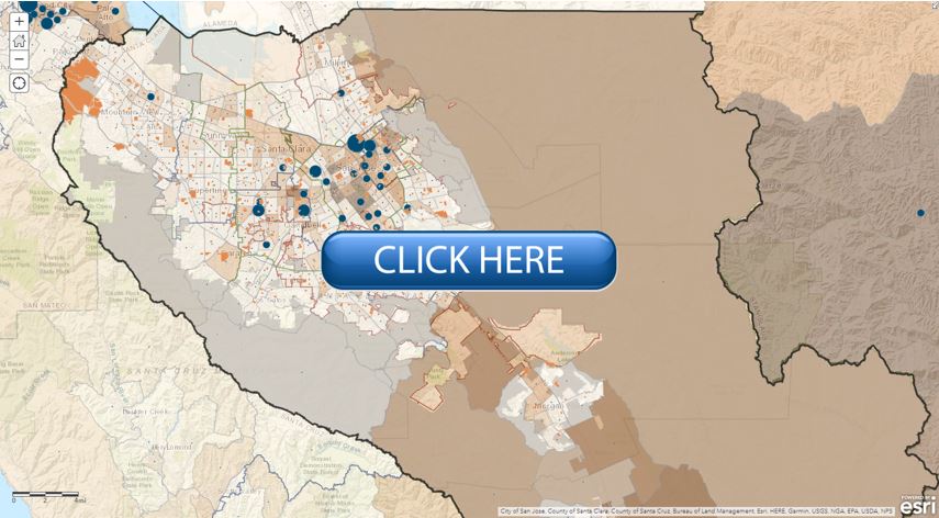
The geography of internet and computing device access varies considerably across Santa Clara County. In general, residents who reside in more densely populated, lower-income areas of major cities as well as those living in rural parts of the county have no or limited access to the internet and/or computing devices.
The SCCOE has developed an online interactive map to visualize these data as well as their relationships with children under the age of 18 who are living at or below the federal poverty level, school sites, and city, school, supervisorial, and congressional districts. Users can access the online map by clicking on the image below.
If new to ArcGIS online, please check out
a walkthrough tutorial on how to maximize the map's capabilities, including adding or removing content layers.